Planning Commission Agenda, 2025-05-08
The municipal agenda for the Planning Commission meeting on 2025-05-08 is 👉here👈
Due to the amount of public engagement this meeting has been reduced to a single agenda item. Other projects have been bumped to a subsequent meeting; mostly to May 22nd.
1050 Leonard St NW
UPDATE 2025-07-26: This tabled agenda item returns to the Planning Commission on the 2025-08-14 agenda.
The Matthew's House Ministry (MHM) is requesting Special Land Use (SLU) to relocate from 766 7th St NW (the intersection of Alpine Ave and 7th St) to this location on Leonard St (the intersection of Leonard St and Powers Ave). Operation of a "Social Service" facility with in a Traditional Business Area (TBA) requires Special Land Use (SLU).
The Existing Site
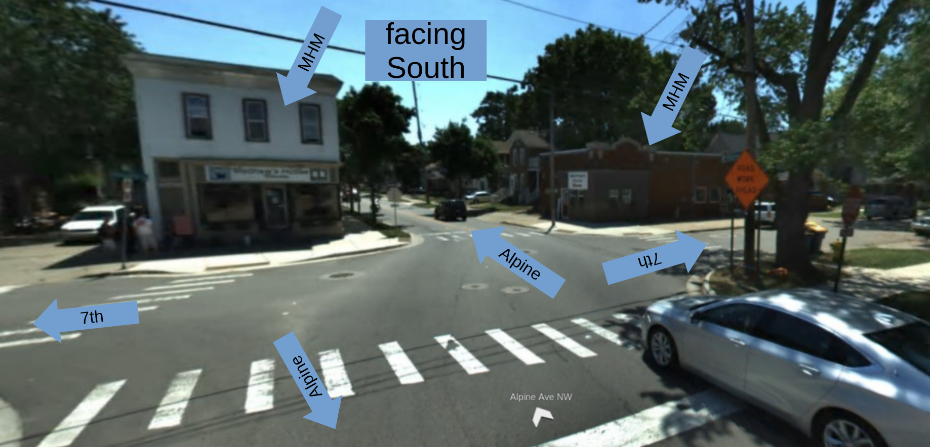
The current site at 766 7th St NW is located in an extremely small TBA zone bordered entirely by LDR (single family) zoning. Tracking from Walker going south Alpine Ave diminishes at Ann St from a dangerous and disgusting stroad to an urban arterial, and then diminishes again as it continues south of Leonard to a two lane road. By 7th St intersection Alpine Ave is a two lane urban street.
The frequent Rapid #9 has stops at this intersection, and is the only transit service within the walkshed of the address.
To the northwest of the 7th St location is an auto service shops, all other adjacent uses are low density residential. While 766 7th St is the address of the ministry they do operate out of buildings on both sides of Alpine Ave at this intersection. Both buildings are traditional corner store types of buildings, one two story and the other one story.
Current Site: Aerial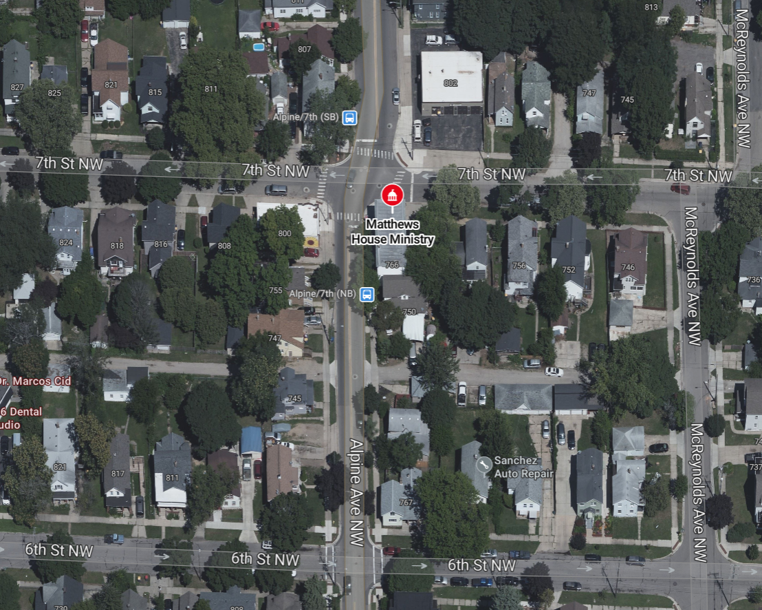 |
Current Site: Zoning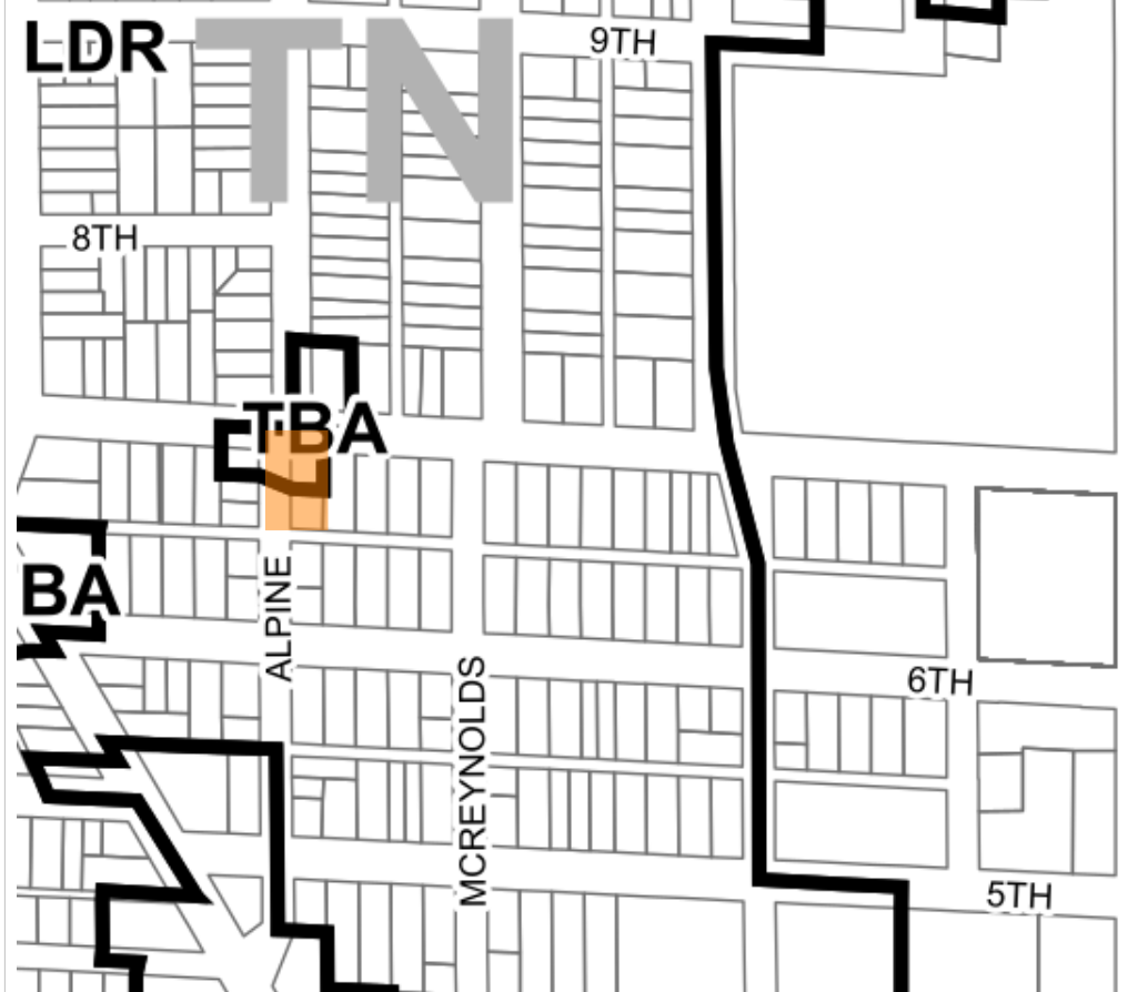 |
 |
|
The New Site
The new [proposed] location is 1050 Leonard St NW, on the south east corner of the intersection of Leonard and Powers; this is six (6) blocks west of the intersection of Leonard and Alpine Ave. The rear of the site is a parking lot on the other side of an east-west alley connecting Powers Ave and Pine Ave. The parking lot and the building at 1050 Loenard are two properties, however they are both currently owned by the same LLC (PS34 LLC).
To the west is a McDonalds with a drive-tru, across the interesection (north west) is a Dollar General and its parking lot, across Leonard Ave (north) is West Leonard Christian Reformed Church, and adjacent to the east is a vacant commercial building (1038 Leonard St NW). All properties to the south are low-density residential.
Proposed Site: Aerial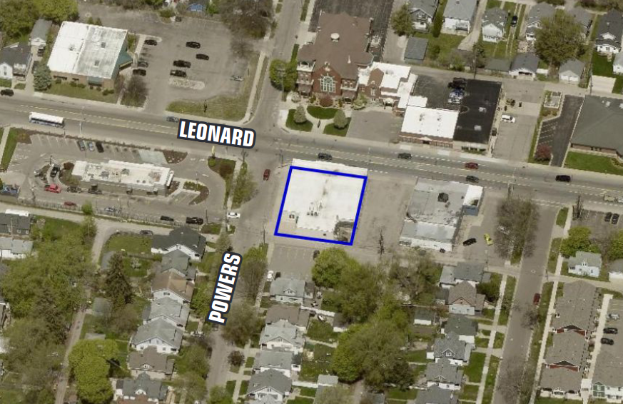 |
Proposed Site: Zoning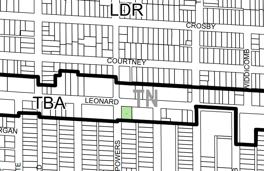 |
 |
|
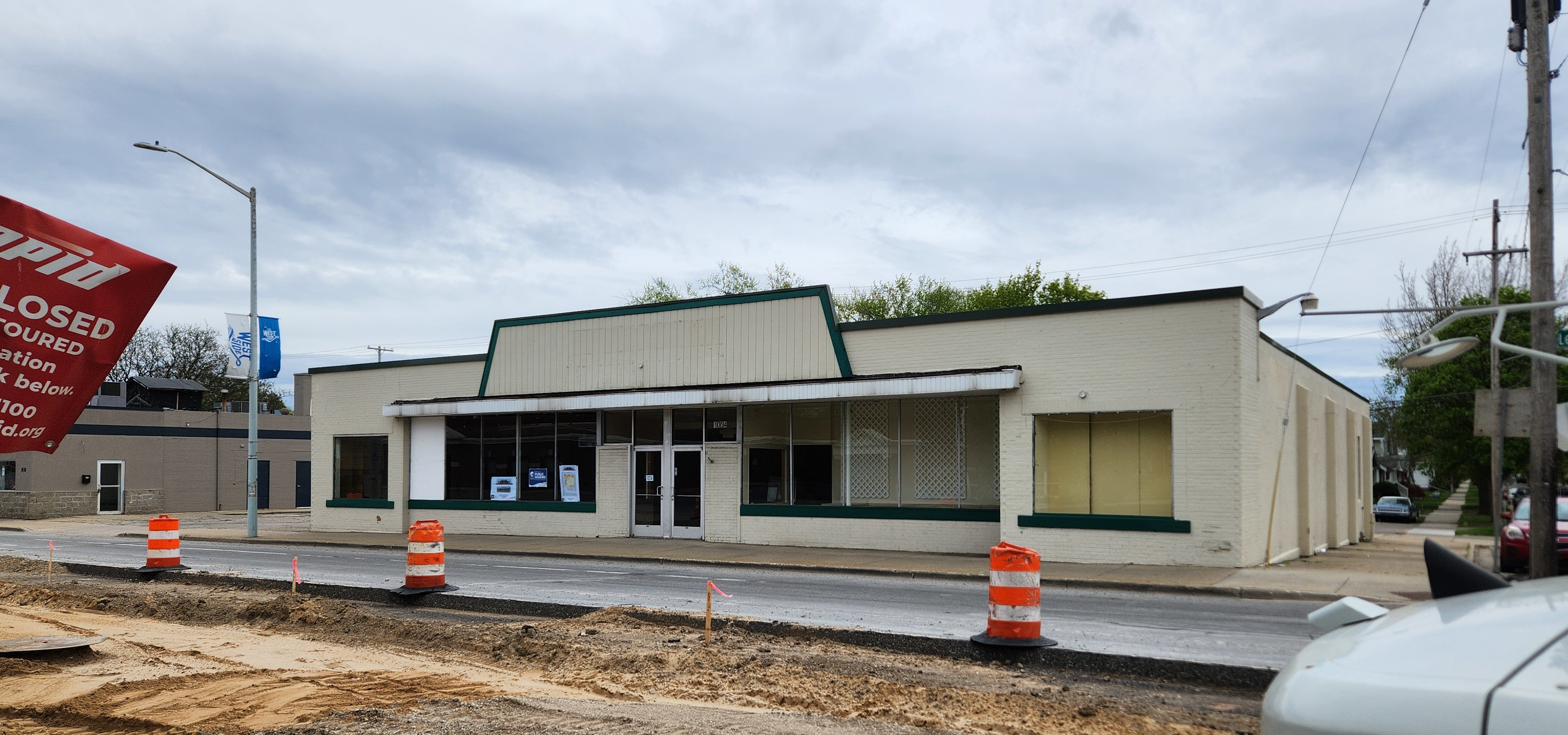
The structure, most recently operated as a thrift store, is a single-story 8,317sq/ft masonry building. The primary entrance faces Leonard St with a secondary entrance at the rear. There are no side entrances or windows facing immediately adjacent properties. The west side of the building, facing Powers Ave, has one window which MHM intends to remove; three windows on this side would be added to bring the building into compliance with current transparency requirements for non-residential buildings. The entirely of the site is paved.
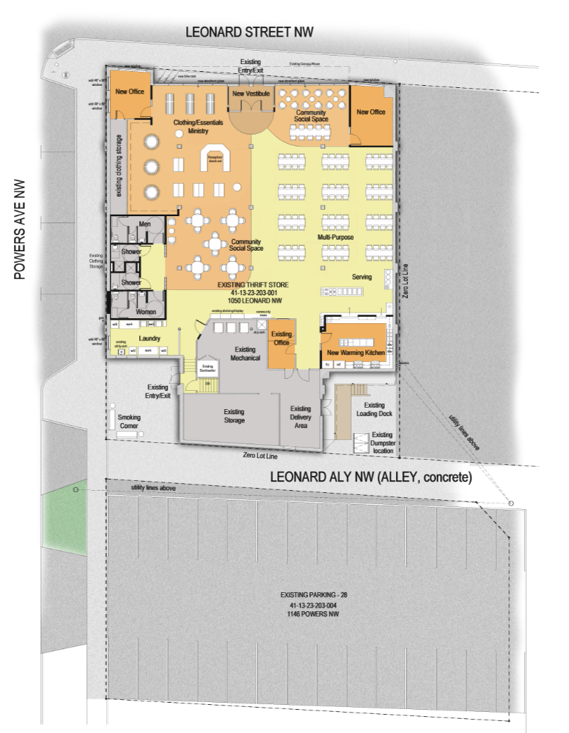
Services will be available at this site Monday - Friday, 8:30am - 4:00pm; a case manager will be onsite during operating hours. Occasional activities will be held during later hours. Means are prepared and served daily. Enumerated functions include, meals, a pantry for both food and essentials, shower and laundry, life skills training, group support sessions, and general social service case management [mental health, substance abuse, job and housing referral, etc...].
The adjacent parking lot, which is under the control of the proposed tenant, provides twenty-six (26) spaces, which is more than the twelve (12) required by the ordinance.
The Considerations
The public feedback for this project aside, the Planning Commission is bound to, principally, determine the appropriateness of a Special Land Use application based upon the standards of city and state ordinances as well as adopted plans. Related to this site are the current zoning ordinance, the newly adopted Master Plan (2024), and the WestSide Area Specific Plan (2015).
Aside: Effective advocacy regarding land-use decisions should focus on the contents of those ordinances and plans, as well as the particulars of the site and its proposed use(s) relative to those plans. It is those documents which define the appropriate uses as well as the restrictions related to a site and corridors. The time to address those definitions is at the time the plan is being drafted. A subsequent application is not the correct time to deliberate the plan; the plan is not what is on the table. An application is considered relative to the objectives of the plan, support or opposition is most effective when it considers an application in the context of the plan's goals. It is advisable to keep one's cultural perspectives and assumptions - we all have them - to oneself. Draft correspondence within the motivational framing of the plan documents: how do the plans support your desired outcome? How do the plans argue against a proposal you wish to see denied? If you can make neither of those arguments work then you need to show up when it is the plan which is on the table. . . . or organize to have your elected leaders put that plan back on the table. The politics of land-use is always a long-game.
The primary use within the proposed site's TBA zone is intended to be consumer oriented commercial activity [aka: storefronts, restaurants, etc...] and the various plans, including the WestSide Area Specific Plan - adopted in 2015 - encourage there being a mix of uses in the corridor.
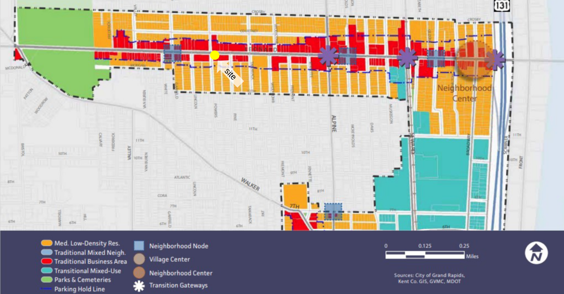
- Intended to respect the historical “storefront” character of the West Side ad encourage a vertical mixture of uses.
- Higher density development to be located at specific corners of primary intersections and first-floor retail uses to create a vital placemaking and pedestrian experience. For this reason, office/service uses should be permitted by special use only.
In the 2024 Master Plan this location is designated as a "Neighborhood Center".
- The intent of a Neighborhood Center is to reinforce a pedestrian and transit-friendly environment in a compact area and promote a mix of small-scale retail, service, entertainment, civic, office and residential uses to enhance the vitality of surrounding neighborhoods.
A Special Land Use application for a social service facility requires the applicant to include a "Good Neighbor Plan" (GNP) which documents how the facility will be managed. The Planning Commission can determine if a GNP is actionable, sufficient, etc... Part of approving the type of SLU is acceptance of the GNP. Matthew's House submitted their GNP. This GNP includes:
- Security staff on site during operating hours, as well as thirty (30) minutes before opening and thirty (30) minutes after opening.
- The installation of security camers for indoor and outdoor areas.
- Visitors are required to check in an out.
- Twice daily litter sweeps.
- Providing outdoor trash bins.
- The maintenance and operation of a phone number and e-mail address for questions and concerns.
- A traffic control plan will be developed in conjunction with the relevant agencies.
The Planning Commission can consider, as part of Special Land Use, the "welfare of adjacent properties, the neighborhood, and the community" in their decision. However, denial on welfare grounds has, by precedent, been required to be clear, specific, and substantiated. I cannot recall a request which was declined on welfare grounds. The most recent similar application - Gianna's in Creston (1410 Plainfield Ave NE) - was granted.
Given that this SLU is for a relocation; a valid question is if this site is more suitable for the intended use than the current site? Both sites are located within TBA zones, albeit the particulars of each site vary substantially.
The Feedback
I generally avoid going into the particular support for or opposition to a given request. That is usually easy to do as most Special Land Use (SLU) proposals go through with no substantive support or opposition! Which does raise questions about the breadth of the restrictions, but that it is a topic for another day. Regarding this project, to not at least mentioning the extensive feedback would feel like a dodge. Primarily I am interested in addressing the feedback in the sense of its validity. So many claims are made in the feedback, often repeatedly, which merit a response. And it is not the role of the Planning Commission, in making a determination for the application, to make that response, it is the role of the community. We should use the significance engagement generated by this project to have a conversation.
Text in this style is snipped from feedback submitted to the Planning Commission related to this agenda item.
You can find a collection of the correspondence in opposition here (PDF), and correspondence in support here (PDF).
Public Safety
-
The family across me on white ave that wont let their kids walk to Richmond park because its unsafe don't want it.)
-
Will school children be vulnerable at the city bus stops?
The majority of the feedback relates in some way to the perception of pubic safety. Particularly in relation to children.
The perception of safety is a fascinating subject. There is also vanishingly little public discourse on the topic, at least locally. In my own neighborhood [Highland park] I have often been told "i would never raise children here"; and I have have talked to neighbors, who upon deciding to have children, have moved out to better areas. As a child, during The Satanic Panic even, I wandered all over the neighborhood. There is a clear division here. I've heard this sentiment expressed, glanced at other neighbors and gotten the acknowledging 🙄. I have learned to [almost always] just let the conversation drop, smile, move on. And I have far too frequently experienced elected and civic leaders, those who are meant to be advocates for our community, indulging this attitude. I would like to see more conversation about the sense of "public safety".
I have my own theory. There is crime, which involves danger to persons and risk to property. And there is a lot of human activity which is better described as disorder; littering, jay walking, graffiti, loitering, etc... These behaviors are not socially positive, however they also do not create danger to a by-stander. The spectrum of disorder to crime seems, IMO, to be compressed, or even hyper-compressed, for many people; where any sign of disorder is interpreted as a sign of danger. While others, myself included, see much less of a, or a less entangled, correlation. Over time I've become more convinced of this hypothesis, I also have very few ideas how to address it. In any case this perception question is critical and has significant public policy ramifications.
The city has adopted a "Crime Prevention Through Environmental Design" (CPTED) policy which is one approach to addressing this topic.
Relevant to the point above between disorder and crime, not all calls to the police department relate to crime. Neighbors often call the police because that is the only people they know to call.
One letter does include call statistics [which I have not verified] which cites fifty (50) calls for "assault" in a ~14 month period at the current MHM site. Assault is crime.
This is false. There has not been an increase in crime. Crime rates in Grand Rapids are low, and if they are not trending down [as in the case of homicide and auto theft] are flat [as in the case of robberies].
What are the effectiveness of things like a Good Neighbor Plan? How is the condition of the site managed outside of operating hours?
There is also a greater question of what mechanisms the city has - and what of those are they willing to use - to enforce compliance?
Aside: I've resided in the city my entire adult life and I will confess to significant - and increasing - skepticism about our Non-Profit Industrial Complex; their effectiveness, their management, and the degree to which they are held accountable for their outcomes and impacts.
Economic Impact
-
Quite frankly, I do not want the corner of Powers and Leonard to turn into the corner of Cherry and Division.
There is something legitimate here. There is no substantial descent from the notion that the conditions at Heartside Park have impacted the economic potential of the Ionia Ave corridor; that the situation there has resulted in prolonged vacancies of commercial properties which are in an otherwise prime location. A potentially important distinction between these sites is that, historically, the decision was made to concentrate social service facilities on the Division St corridor and the related area. There is no established concentration of such services on West Leonard. Are the concerns demonstrated by that site (Heartside Park) applicable to this site?
The plans all encourage a mix of uses on corridors in order to avoid the side-effects which come with any type of concentration of one use.
False. Any "property values" argument can be discarded. However much conventional wisdom exists, no, affordable housing, etc... has at the very worst a negligible impact on adjacent property values. There are abundant studies; anyone making this claim is demonstrating they did not bother to read anything about the topic.
Also, if you own property in Grand Rapids and have experienced a decline in property values within the last decade please raise your hand? 🦗 🦗 🦗
If you want to oppose some land use decision you need to try harder than "property values". Your property's value is doing just fine.