Planning Commission Agenda, 2024-08-22
The municipal agenda for the Planning Commission meeting on 2024-08-22 is 👉here👈
Don't forget to participate in 👉Mobile GR's current mobility survey👈.
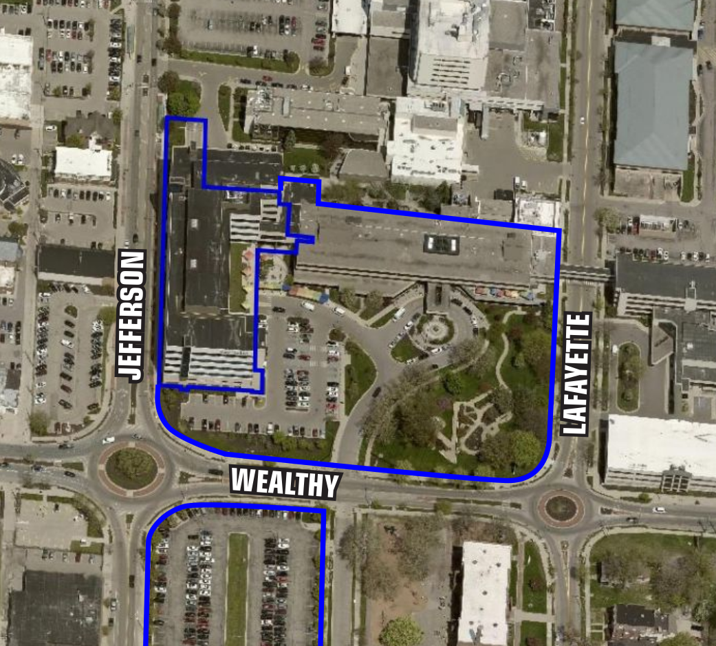
220 Wealthy St SE
This is a different one; a Special Land Use (SLU) request to build a 225 foot long pedestrian bridge. In this case a pedestrian bridge to link 220 Wealthy St SE and 320 Jefferson St SE. The site of 220 Wealthy St SE is intended to be a three story children's rehabilitation hospital. 320 Jefferson St SE is the current Mary Free Bed West building. Both properties are part of the Mary Free Bed Rehabilitation Hospital campus.
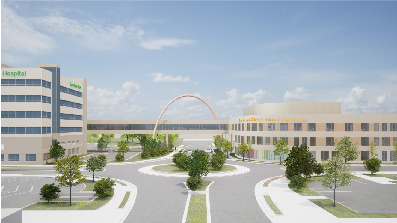 |
Yes, there are specific provisions for pedestrian bridges in the Zoning ordinance! Pedestrian bridges are required to be transparent (clear glass), to completely span the street (no supporting columns), meet the buildings at a level grade, and be a minimum of sixteen (16) feet above the road. This bridge meets all of these criteria, and will be twenty-six (26) feet above the road.
 |  |
Within urbanist space there is a long running conversation about pedestrian bridges and their socio-spatial impact. This pedestrian bridge being part of a medical complex and not for the general public exempts it from the discussion IMO. The downtown Grand Rapids sky-bridge network [from Van Andel area to the convention center] is not an exception. Both the city's 2002 Master Plan and the 2015 GR Forward plan emphasize street activity, and the purpose of sky-bridge connections is to take people off the street. And while the sidewalk is the public realm, the sky-bridge network is only a quasi-public space which passes through privately owned structures. There is a perspective that sky bridge networks represent a two-tiered system, with those welcome in the quasi-public realm passing over and looking down on those who are not. Those welcome in that network exempted from the consequences of our nation's and city's neglect of the public realm; including the prioritization of the automobile over the human. A less damning, but still damning take, is that sky-bridges are the American Urban Planners response to their own failure; too inept to design the comfortable and safe streets seen all around the world, well, they gave [some, perhaps not all] people a way to bypass that failure.
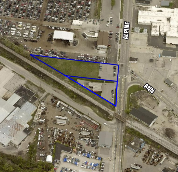
1947 Alpine Ave NW
The applicant JARS Holdings LLC, a cannabis retailer, is requesting a rezoning of a property from SD-IT (Industrial Transportation) to TCC (Transitional City Center). The parcel is adjacent to a TCC zone, which includes a maintenance facility of the Grand Rapids Eastern Railroad [which is not zoned SD-IT?]. Have we ever mentioned that zoning is weird and arbitrary? I guess the railyard and metal working facility south of the railroad is buffering the sacred single-family zones from the intense land-uses of downtown? ? ?
 | 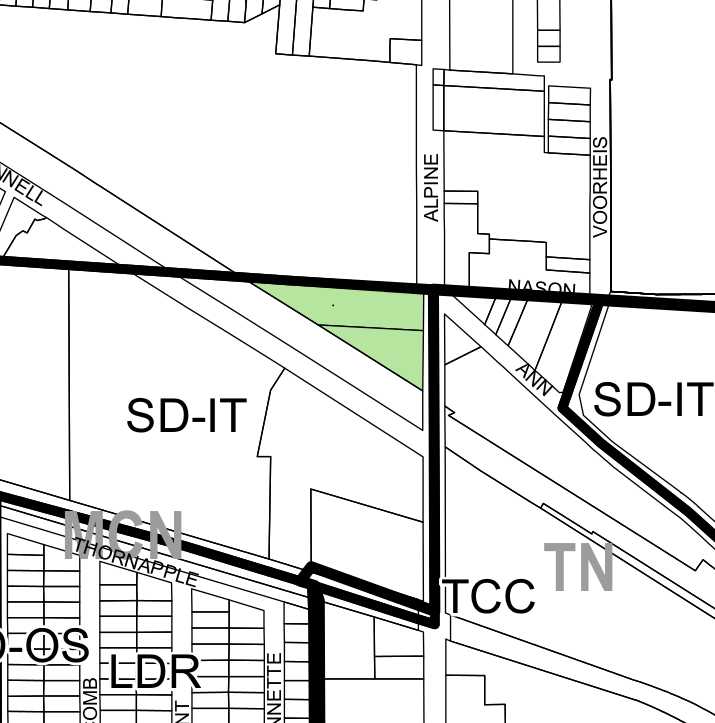 |
Retail uses are not permitted in SD-IT zones. Transitional City Center zoning allows just about everything.
This rezoning will represent another erosion of land within the city zoned for for industrial uses. Industrial uses create well paying jobs and support follow-on economic activity. On the other hand the zoning restrictions around cannabis uses are legion and the business in question would have a difficult time finding an alternate location.
This is an interesting agenda item. Does the city rezone property on behalf of a single bushiness / retailer? As a compensation to the constraints of its own regulations? How binding are all the stacks of plans which underlie the zoning classification of a property?
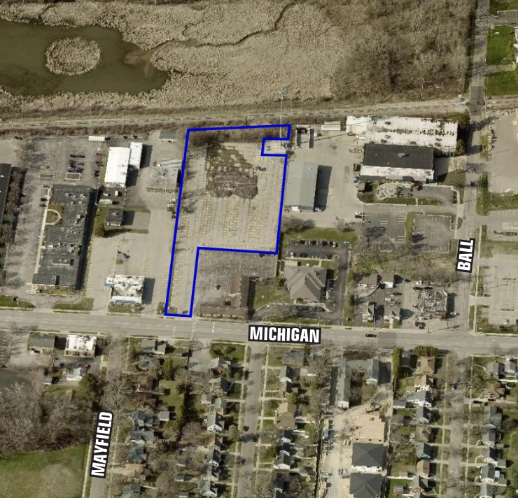
1503 Michigan St NE
This agenda item is a request for Special Land Use (SLU) to construct a three-story (37ft) self-storage facility with an outdoor storage yard. Self-storage is a permitted use it SD-IT (Industrial Transportation) zones if a site is at least three (3) acres, which this site is not; also there is the question of the outdoor storage yard. The sire is 2.6 acres.
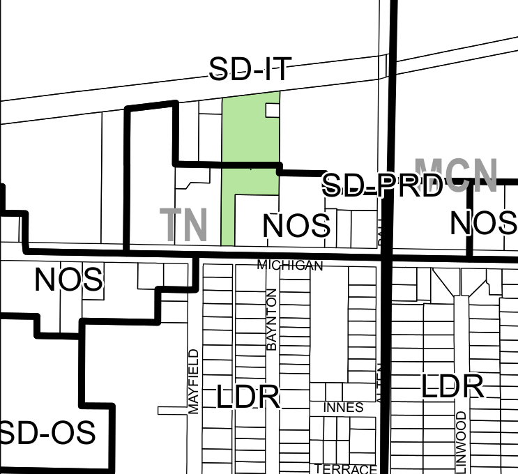 |  |
This site is included in the Michigan St Corridor Plan which recommended the use of light manufacturing. As with the previous site it is adjacent the Grand Rapids Eastern Railroad. Permitting self-storage on this site would, as with the previous site, reduce the amount of land available for potential industrial development.
The current conditions of the site are as a 265 space parking lot. This lot was previously used by Corewell Health, before they decided to double-down on a thoroughly suburban approach to development and operation. A crossing signal once existed at this site and Michigan St which was intended for the riders of the now cancelled Rapid route #19 which provided cross-town service on Michigan St and Bridge St with 15 minute head-ways. Corewell's lease on the property will expire in 2025 - by which time they will have built thousands of parking spaces in the urban core (so much for "health").
The property, which is set back behind another property, is accessible from Michigan St. The proposed structure will contain ~670 storage units. The storage yard will be located to the north of the structure, between the structure and the railroad. It is a condition for storage yards to be completely screen from public view and not visible from adjacent properties.
A truly hilarious requirement is a parking space for every 1,000sq/ft of storage - so this development for a storage facility requires 103 (one hundred three) parking spaces. 🤣 Yeah, whatever. The developer proposes fourteen (14) parking spaces. This extreme case is sue to the zoning ordinance's assumption that self-storage means individual garages, the kind of self-storage one sees in areas where property values have been destroyed, and potential uses limited, by the presence of load and dirty highways . . . oh, right.
There is an interesting footnote, regarding if this site should be considered SD-IT or NOS (Neighborhood Office) due to the front parcel being zoned NOS:
With the adoption of the 2008 Zoning Ordinance and Map, the subject parcel was erroneously split with the northern +/-1.6 acres in SD-IT and the remaining +/-1.1 acres in NOS. The Zoning Ordinance allows the Director to interpret a zone district boundary after reviewing the lot line and district placement. In this case, it has been determined that the zone district line should follow the parcels fronting along Michigan Street as the unique condition of the 1503 Michigan St. NE has created uncertainty it would be appropriate to have the zone district lines follow property lines and keep the existing land use intact (Sec. 5.2.05.B.4. and Sec. 5.4.05.C.).
Remember, zoning's promise is predictability.
640 Leffingwell Ave NE
This Special Land Use (SLU) is a bundle of requests. The owner of this industrial site intends to be taller than the zone district allows, have a metal exterior (not permitted), and build up to twenty five (25) feet from natural features.
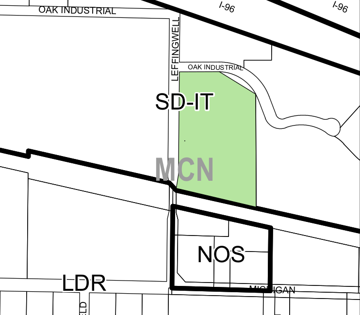 | 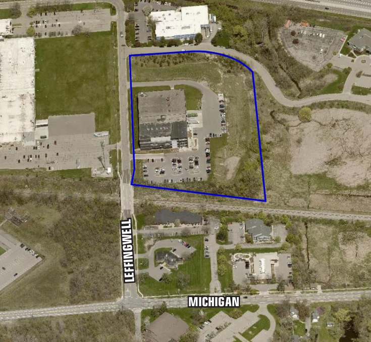 |
The proposed building additions is 130,600sq/ft. A portion of this building will be twenty (20) feet from Oak Industrial Drive, a twenty five (25) foot setback is required. The height of the addition will be fifty one (51) feet; the SD-IT zone has a height limit of forty five (45) feet. The current building is four (4) stories, a height of fifty nine (59) feet.
The parking requirements for the site, after the addition is constructed, will be 260 parking spaces. The redesign of the site provides 260 parking spaces and fourteen bike parking spaces.
News
- Personal protection equipment manufacturer to more than double Grand Rapids HQ , Crains 2024-08-26