A Look At The Draft Master Plan

The final engagement phase of the new master plan development process has concluded. And there is a draft plan (PDF, 80MB). At some point in the near-ish future a final proposed plan will become available and then that plan will rest for a sixty-three (63) day comment period.
As with the previous 2002 plan the new plan is broken down into topical chapters. The current draft plan has six (6) chapters, the previous plan had ten (10) chapters; technically it had twelve (12), however it treated the introduction and overview as chapters while the draft does not enumerate those as such.
The line-up of the chapters (each chapter link in this table links to the corresponding PDF):
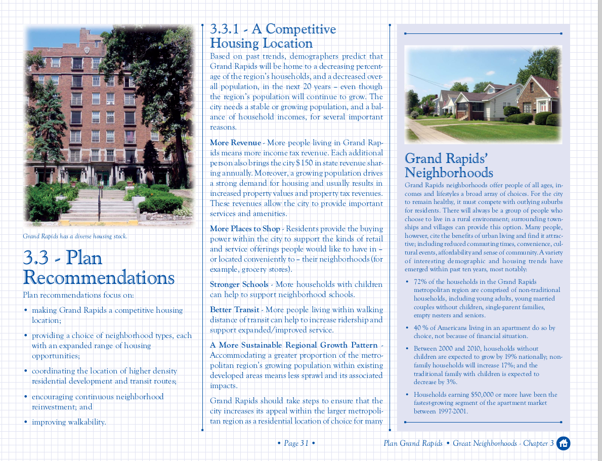
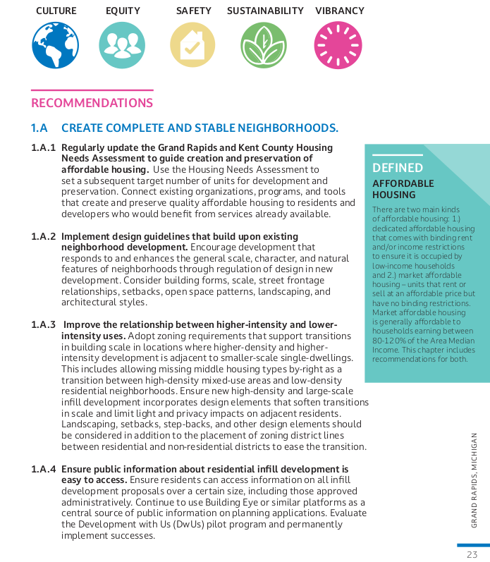
Upon review the first comparison it is impossible not to notice is the sharp stylistically different. The new document (perhaps because it is a draft?) is a simpler more bullet-point style of document, almost having a Power Point vibe vs. the 2002 Plan which was more a more ornate presentation. If only considering the ease of reading the newer format is an improvement.
2002 |
2024 |
Big Diferences
Some of the more substantive changes in the document overall are:
- The new draft discussed Racism, directly. The 2002 Plan does not refer to the racial discrimination responsible for much of the built-environment, societal conditions, and economic inequality we experience today.
- The new draft discusses Climate Change, directly. The 2002 Plan contains no reference to Climate Change. As near as it gets is to reference the "the consumption of nonrenewable resources." (Ch#8: A City in Balance with Nature).
Data
It wouldn't be UrbanGR if we didn't compare and contrast come of the data presented in the Master Plans! It is interesting both in what each time chose to highlight, and how the trends have moved where they overlap.
2002
- 72% of the households in the Grand Rapids metropolitan region are comprised of non-traditional households
- 40 % of Americans living in an apartment do so by choice, not because of financial situation.
- Households without children are expected to grow by 19% nationally; non-family households will increase 17%; and the traditional family with children is expected to decrease by 3%.
- Households earning $50,000 or more have been the fastest-growing segment of the apartment market between 1997-2001
- The city's only population loss occurred in the 1970s; contrary to common perception the city was already in population recovery in those dark & gritty 1980s.
2024
- 88% of public engagement participants identified housing as a key concern, specifically highlighting the need for more affordable housing and different types of housing.
- Grand Rapids has 12,680 studio or 1-bedroom units, and 52,001 one- and two-person households (66% of all households). There is a clear mismatch of housing types with household composition. Grand Rapids needs more small-unit housing.
- The Grand Rapids area is ranked 9th among US large metros for small business employment. Over half of Grand Rapids workers (50.4%) are employed by small businesses.
- On average, 20% of a household’s annual income in Grand Rapids is spent on transportation; the national average is 16%.
- ~80% of residents live within a 10-minute walk of a park
- Over a third of the city (~35%) is extremely low density residential (single unit dwellings).
A data-point not included in the 2024 Draft is that America is currently at a record high of multi-generational households. The US census estimates that multi-generational (three or more generations) increased from 4.7% in 2020 to 7.2% in 2020; a +2.5% shift in ten years, an increase from 5,100,000 households in 2010 to 6,000,000 households in 2020. The nuclear family is a minority of American households; we should design our cities to accommodate that fact rather than our Ward & June Cleaver fantasies.
Overall
Much is repeated from the 2002 Master Plan as well as other more recent plans (GRForward, etc...). This is not a criticism, many of the [re]stated objectives are obvious: encourage more Accessible housing, equal distribution of parks and recreational facilities, ... These goals likely exist in the majority of Master Plans in cities across the nation. Grand Rapids has demonstrated that it is very good at some things. Adaptive reuse is one. Last I heard the topic discussed there are zero big-old-buildings waiting for a developer - perhaps a few of these projects are floundering, that happens - but everywhere someone is trying. This is a different world than 2002 when the notion of converting big old industrial buildings to residential or other uses was not an obvious move. We owe much of that success to the 2002 Master Plan and the leadership the city was fortunate to have at the turn of the century with Mayor Logie [1991 - 2003] and his successor Mayor Heartwell [2004 - 2016].
Chapters
Let's look at the chapters of the new draft and pick out the bits which appear to reflect a substantive departure from the previous plan, or are remarkable in some way.
Ch#1: Great Neighborhoods
This is the chapter about housing.
| 1.A CREATE COMPLETE AND STABLE NEIGHBORHOODS. Complete neighborhoods provide a mix of housing types in close proximity to centers and corridors and give residents convenient access to daily needs, employment, recreation, and transportation options. |
The Great Neighborhoods chapters seems to assume a continuation of the current euclidean zoning, the segregation of uses, with residential distinct from other land-uses. Note the proximity to centers and corridors, not that the neighborhoods would be complete by having the uses mixed throughout. Neighborhood shops, corner stores, or ACU (Accessory Commercial Units) are not par of the plan. Retail is not mentioned in any objective, and only once in the opening paragraph of the chapter. This stands out as a not particularly urban conceptualization of the "complete" neighborhood.
| 1.8.2 Allow duplexes, triplexes, quadplexes, and ADUs by-right in zoning districts where single-family housing is allowed. |
The inclusion of this is interesting as the city already did this, this year (finally). Will there be a further expansion of by-right development opportunities in the subsequent Zoning Ordinance? The draft is extremely vague as to what this means. What does "where" mean?
| Create explicit definitions of cooperative and co-housing in the Zoning Ordinance and incorporate as permitted multi-family uses. Make cooperative housing a Special Land Use requiring Planning Commission approval. |
Again, this is something which reflects a non-change. Co-housing is a Special Land Use in the current Zoning Ordinance.
| Allow higher density residential in the Mid-Century and Modern Era neighborhoods. In line with the Vital Streets Plan, increase density in neighborhoods where adequate transportation infrastructure is provided. . . . Consider allowing up to six units on lots fronting Link Residential and Network Residential streets in all zones where single-family detached dwellings are permitted |
Once again, this is something the city recently did. Is this a signal that the status-quo is the future? It is difficult to read this chapter in any other way.
| 1.B.5 Continue to increase home ownership opportunities. . . . Streamline the process to create condominium forms of ownership. |
If encouraging home ownership is to continue to be a goal of the Master Plan there is the question: How? The era of the Detached Single Family Unit (aka: the House) is drawing to a close, the city is built out. There are not abundant vacant lots. If ownership is a desirable feature then we need more kinds of ownership. Condo-ization is complex, streamlining this is good.
Ch#2:Vital Business Districts
| 2.A.2 Direct dense development downtown and in areas and corridors served by regional transit routes. The GR Forward Downtown & River Action Plan, adopted in 2015, called for increasing the downtown residential population to 10,000 people. Evaluate and update this number to significantly increase the new downtown population goal. |
I have not heard a reference to the GR Forward population goal in years. Someone asked at a recent meeting of the DGRi meeting what that goal was? Nobody spoke up as remembering.
I have mixed feelings about steering dense development towards downtown, because: why not in the neighborhoods? OTOH, getting downtown Grand Rapids above its paltry density of 6,705sq/mi would be a huge benefit to the downtown core. Currently the highest density is not downtown but the neighborhood of East Hills!. Meanwhile downtown is flush with infrastructure, particularly transportation infrastructure, capable of supporting an order of magnitude greater population density.
So, 2.A.2 can be read as either yet another genuflection to the status-quo, or a directive to maximize the assets we already have.
| Consider setting minimum Floor Area Ratio (FAR), residential densities, and/or number of stories on sites within a certain distance of regional transit routes to ensure these areas are developed to an appropriate density. |
The word minimum. 🙂 Now we are talking. There is little more disappointing than a BRT station surrounded by two story buildings. What are we doing??? Once something is built, it is there for decades. The city has been extremely lazy in the husbandry of its assets. It took the City five years from the beginning of the operation of the Silver Line to have a plan for the corridor, after the Silver Line was in development for two years. And that was a period of robust economic prosperity and historically low interest rates. The squandered opportunity of the late 2010's under Mayor Bliss is heart-breaking. It is time to get serious, this could be an important step.
Aside: "FAR" (Floor Area Ratio) is Urban Planning speak for the ratio of stuff to space. A single story building occupying the entirety of its lot has a FAR of 1:1, a two story building a FAR of 2:1, etc... More stuff in space is, generally, better Urbanism. Because density is an economic good. This is in contrast to something like a Detached Single Residential Unit (aka: a House) which can have a sub-one FAR, like 0.3:1. 😢
Ch#3: Strong Economy
| 3.A.1 Consider a hybrid business use category within Innovation Districts identified on the Future Character and Land Use map ...
.. 3.B.4 Reposition underutilized commercial properties to support non-retail businesses. There are potential commercial and retail sites that might be better suited to a broader employment land scenario, including research and development and light manufacturing that doesn’t impact nearby residential uses (e.g., 28th Street) ... 3.C.2 Amend the zoning ordinance to reduce the impact of industrial uses on surrounding areas. The City should consider code amendments that differentiate between light industrial and heavy industrial zoning districts. . ... |
All these run together. One of the most common justifications Urban Planners use for the onerous regulation of a city via a Zoning Ordinance is that the ordinance protects residential areas from smoke-stack industries. Obviously, nobody wants Bethlehem Steel to build a steel mill right next to their beautiful cottage court co-housing development! Only, this is 2024, not 1933. "Industry" is not what it once was in the era of steel mills and steam locomotives. In 2024 industry - particularly manufacturing - means stable well-paying jobs. Updating our notions of "industry" is essential to creating a city with economic opportunity beyond the Creative Class. And that Creative Class, ultimately, has a parasitic relationship to actual industry (which makes things), and is just as dependent on the success of those industries as the welder, CNC operator, or assembly line worker.
Ch#4: Balanced Mobility
We no longer use the term "transportation", these days it is "mobility". What does "balanced" mean? I have no idea. Overall I assume it means the city will continue to pander to Motorists while attempting to make changes on the margins. "Vision Zero", which the city adopted ~6 years ago, sounds so ambitious, without engendering any commitments. 😢
| 4.C.1 Reduce minimum parking requirements to support compact growth patterns. |
In 2024 it is difficult to be impressed with "reduce". 😢 Other city's in Michigan have eliminated parking requirements. It is time.
| 4.C.2 Limit the size of surface parking lots. Minimize the impact of surface parking lots downtown and in business districts by setting maximum sizes on modified lots. . . . Consider restricting the creation of new surface parking to prioritize space for people. |
YES! The current Zoning Ordinance already has parking maximums, however the Planning Commission is allowed to waive those maximums, as this did for Corewell Health in Monroe North. Let's have some real maximums.
In terms or repeating without expanding goals of the 2002 Master Plan this chapter seems to tie with chapter #1 (Great Neighborhoods) in staying close to the status-quo.
Ch#5: Desirable Character
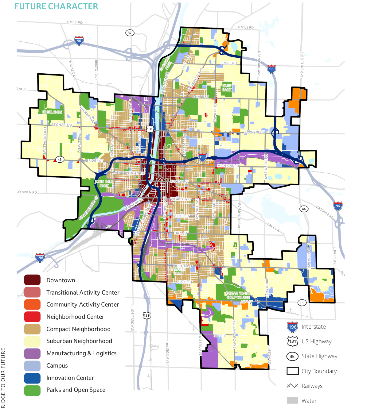
Hmmm.... The 2002 Master Plan created the hybid zoning system of TN | MCN | MOD / LDR | MDR | HDR (Traditional / Midcentury / Modern + Low Density / Medium Density / High Density) zoning which was rather particular to Grand Rapids. This chapter implies what could be largest change to most neighborhoods: the reduction of that 3x3 zoning matrix to two categories. Compact neighborhoods and suburban neighborhoods. This has to be respected in, at least, it's honesty. Yet, again, Hmmm... The devil is in the details, as to what this really means. There is a lot of room in the text which could allow for keeping the status-quo.
This chapter describes ten (10) zone categories.
- Downtown : what you'd expect, tall buildings build up to the sidewalk and minimized drama about uses.
- Transitional Activity Center : relates to the current Transitional City Center and TOD zones (we have TOD zones???). These zones are basically a step-down from the Downtown zone with mid-rise buildings built up to the sidewalk.
- Community Activity Center : shorter to mid-rise buildings clustered around major intersections with active ground floor uses. This can include "big box" type development and traditional auto-oriented shopping centers.
- Neighborhood Center : neighborhood scale [three stories or less] mix-use development along corridors or clustered at intersections. This looks much like the "Traditional Business Area" (TBA) of the current zoning. Why the limit to three stories? That feels extreme.
- Compact Neighborhood : This is essentially what was previously the "TN" (Traditional Neighborhood) part of the city; pre-war residential. It does call about allowing commercial and civic uses at intersections or along major streets, something which was notably absent from the Great Neighborhoods chapter. it is encouraging to see that here.
- Suburban Neighborhood : While the label makes be bristle, it is honest. My own neighborhood of Highland Park is split on the land-use map into Compact Neighborhood and Suburban Neighborhood exactly where I would expect; were the street grid begins to lack alleys and be broken up by cul-de-sacs. Both duplexes and accessory dwelling units (ADUs) get a call-out in this section; so we'll have to wait and see what happens in the Zoning Ordinance if the city is going to continue to let the outer neighborhoods off the hook in the need to accept change.
- Manufacturing & Logistics : Large scale, potentially noise and dirty uses. Yet uses with are essential to not only to a robust economy but the existence of modern human civilization.
- Campus : this is an escape hatch to let large institutions do what ever they want. 😢 Like building sprawling suburban style campuses or office parks over the top of urban neighborhoods. Probably a necessity, but we don't have to like it. Advocacy and community organizations will need to keep an eye on these zones, and what the city is promising to whom.
- Innovation Center : Huh. This feels like the wildcard zone; everything from religious to light-industrial uses are mentioned. And on the land-use map it appears to be applied to area's where the city doesn't have a feel for what direction an area is going to go. Given that modern technology makes even functions like manufacturing cleaner, quieter, and lower impact I am comfortable with the wildcard zoning and would probably draw these areas even wider. OTOH, it isn't clear at all what this means in terms of guiding the form of what gets built. Again, we'll have to wait to see the Zoning Ordinance.
- Parts & Open Space : Yep, parks.
This chapter does contain the "future character" land-use map, which is worth looking at.

End Note
The absence of an equivalent to the 2002 Master Plan's Ch#7: A City That Enriches Our Lives is interesting. If you have any familiarity with the city's GR Forward plan this chapter should be interesting, it very much lays the foundation for what would be come the GR Forward plan. This chapter included an emphasis on building access to the river as a community third-place into the city's core planning play book. With a new master plan what is the status of the other existing plans, most notably GR Forward which is a guiding document for the Downtown Development Authority, but also other plans like pre-existing Area Specific Plans (ASPs) and corridor plans?
As you look at the Master Plan draft - a document which will influence the development of the city for a third of a life-time - what stands out to you?
