A Look At The UZA
Let's take a look at the Federally defined Urbanized Area (UZA). This is in contrast to the city, and the generally meaningless Metropolitan Statistical Area (MSA) which is most commonly cited. The appealing aspect of the UZA is that it represents a geographically contiguous area, usually clearly defined by the underlying infrastructure. It is also fun to say.
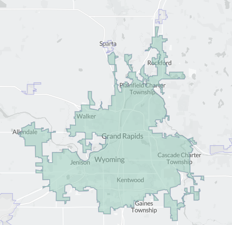
So, where is the Grand Rapids UZA?
Population: 609,023
Area: 280.5 square miles
Population Density: 2,170.8 people per square mile
Median Age: 35.4, 62% of the population is "working age" (18 - 64)
Race & Ethnicity: 69% white, 12% hispanic, 10% black, 3% asian, 5% multi
Per capita income: $40,620 [slightly below national average: $41,804]
Median household income: $76,686. 37% of households have an income over $100,000/yr; 31% have an income below $50,000/yr.
Mean commute time: 20.2 minutes (73% drive-alone to commute)
Housing units: 249,641, vacancy rate is ~4%. 67% of housing units are owner-occupied. 69% of housing units are single unit detached.
Households which move in a given year: 14.3%
The region you likely hear talked about the most, much more often than the UZA, is the Metropolitan Statistical Area (MSA), here's the map:
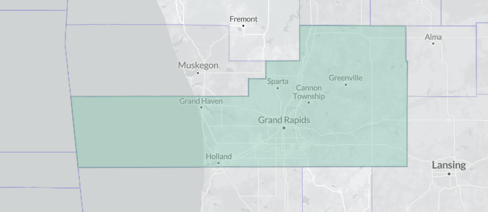
If your reaction to that this "Huh", I agree. I feel talking about things on the MSA level is mostly absurd. I'll highlight that further in a moment. But first let's look at a straight-up zooming out, from the city, to the UZA, the MSA, the state, and the nation:
| Area | Size | Population | Median Age | Working Age | Income (per capita / household) | % Households over $100k/yr | Mean Commute Minutes | % Households moving per year | % White |
|---|---|---|---|---|---|---|---|---|---|
| The City | 44.8sq/mi | 196,904 | 33.1 | 67% | $38,558 / $65,660 | 28% | 19.4 | 20.1% | 62% |
| The UZA | 280.52sq/mi | 609,023 | 35.4 | 62% | $40,620 / $76,686 | 37% | 20.2 | 14.3% | 69% |
| The MSA | 2,689.1sq/mi | 1,094,198 | 36.6 | 61% | $39,022 / $77,771 | 36% | 20.6 | 13.5% | 76% |
| Michigan | 56,610sq/mi | 10,034,118 | 40.3 | 60% | $38,151 / $66,986 | 32% | 24.2 | 11.6% | 73% |
| USA | 3,537,296.5sq/mi | 333,287,550 | 39 | 61% | $41,804 / $74,755 | 37% | 26.4 | 12.6% | 58% |
Given the difference in the maps you'd expect the UZA and the MSA to have a greater difference between each other. The key factor to remember is that each contains the other; the MSA contains the UZA which in turn contains The City. So what if we back these out to the degree possible:
| Area | Population | Net Population | % Population | Sq/MI | Net Sq/MI | % Sq/MI | Population Density |
|---|---|---|---|---|---|---|---|
| The City | 199,800 | 199,800 | 18% | 44.8 | 44.8 | < 2% | 4,460 |
| The UZA | 609,023 | 409,223 | 37% | 280.52 | 235.72 | < 9% | 1,738 |
| The MSA | 1,094,198 | 485,175 | 44% | 2689.1 | 2408.58 | ~90% | 201 👈 ZOINKS! |
Population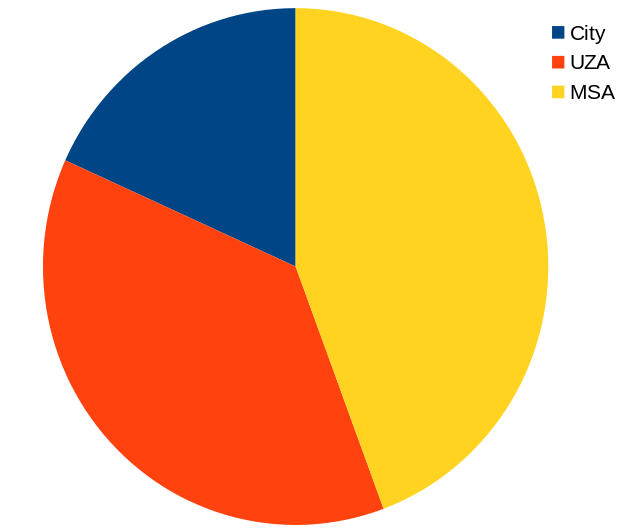 |
Land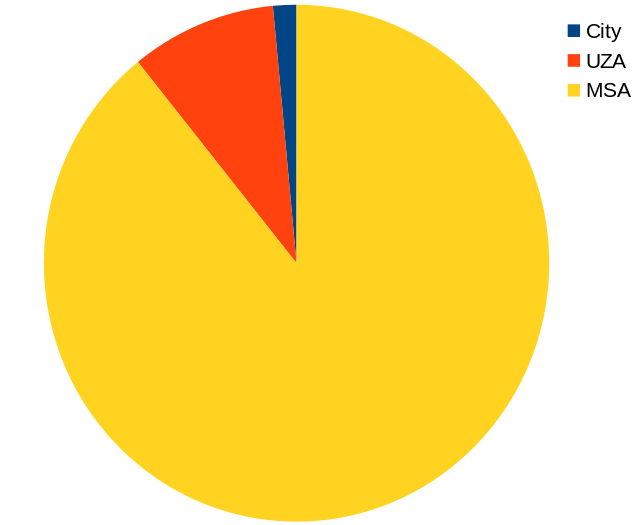 |
Yes, I think we can lay to rest any notion that talking about the Metropolitan Statistical Area is anything other than nonsense. Just for fun, and to put some more nails in this solidly closed coffin, here are a few zip codes from within the MSA:
| Zip Code | Size | Population | Density | Median Age | Working Age | Income | % Households > $100k/yr | Mean Commute Minutes | % Households moving per year | % White |
|---|---|---|---|---|---|---|---|---|---|---|
| 49503 | 7.3mi | 37,005 | 5,097 | 30.4 | 72%👈 | $32,043 / $52,441 | 20% 👈 | 18.7 | 26.7% | 58% |
| 48809 | 80.1sq/mi | 11,340 | 141.6 | 38 | 51% | $27,138 / $59,640 | 25% | 30.7 | 11.1% | 93% 👈 |
| 48884 | 61.3sq/mi | 4,861 | 79.3 👈 | 43.6 | 58% | $28,268/ $54,616 | 22% | 31.6 | 7.8% | 94% 👈 |
| 48849 | 83.7sq/mi | 5,762 | 68.8 👈 | 38.2 | 58% | $31,202 / $70,451 | 29% | 28.2 | 9.2% | 93% 👈 |
| 49464 | 73.1sq/mi | 29,060 | 397.3 | 38.2 | 59% | $39,156 / $86,742 | 41% | 17.9 | 8.2% | 85% |
| 49512 | 23sq/mi | 18,245 | 792.7 | 33.8 | 66% | $38,331 / $55,346 | 28% | 18.9 | 20.8% | 67% |
These are some astonishingly different places! And all within the "Metropolitan Statistical Area". Which is why I like the UZA so much more as a meaningful geographic grouping.
Take a few moments and look at this data; or follow the links and look around yourself. I believe, in a slow and quiet way, this data tells a story about not only West Michigan, but Michigan as a whole. There is a vision of Michigan as a sprawling auto-centric place. Things like public transportation can't work here, right? But look. The reality is that most of the MSA is empty. The population is surprisingly concentrated. Michigan is an urban state, its population is heavily concentrated in cities. One of the most suprising facts about Michigan - which shocks most people the first time they hear it - is that 80% of Michigan residents live within 25 miles of an Amtrak station. I know, right? It is not as if we have robust passenger rail service. It is that the states population is very concentrated along a few corridors, and the rest is mostly empty. And those concentrated areas are becoming more concentrated, and those empty areas are only becoming emptier. This is a hopeful thing. I think of the state of Michigan as a long neglected, now ramshackled, old house with enormous lawns and gardens. All it needs is some industrious new tenants to come along and love it for what it is. Michigan has "great bones". With what is still the largest concentration of manufacturing jobs in the United States, a booming medical sector, numerous universities, and the potential to be a climate refuge, the cities of Michigan (Holland, Grand Rapids, Kalamazoo, Lansing, Ann Arbor, & Detroit) could be linked into a super-corridor [hint: the rail infrastructure is all there!]. Imagine it! What is needed? Leadership. I hope, sooner rather than later, the younger generation(s) will throw-the-bums-out and restore the dignity of this dingy old house.
And let's stop talking about the Metropolitan Statistical Area.
Sources
- Grand Rapids, City of, Census Explorer
- Grand Rapids Urbanized Area, Census Explorer
- Grand Rapids Metroplitan Area, Census Explorer
- The State of Michigan, Census Explorer
- The United States of America, Census Explorer